Christian Aid Water Walk
summary
With the advent of climate change all of us have a responsibility to use water wisely and here in the west we know just how important water is to our health, food and economy. It drove the industrial revolution, through water mills and canals, then steam power. Today we can turn on the tap and get a glass of water any time, make a cup of tea or coffee, take a bath or shower after exercise or just to relax. Consider how much water you use in a day, how many cups of tea etc. and then think about having to carry all that water for miles and how you are going to use it – cooking, washing, watering crops and so on.
This walk can be done as a whole or in sections, some areas are uneven and field walking, other areas are more accessible and on the level.
This walk can be done as a whole or in sections, some areas are uneven and field walking, other areas are more accessible and on the level.
Details and start point
Distance: 5 miles
Distance: 8 km
Walking time: 2.5 hours
Grid Reference: SO752021
What 3 Words: forecast.latter.escapades
Share this walk with your friends:
Print Walk
Step by Step Directions
1
Turn left out of the station car park and walk a short distance on the road to the junction of Halmore Lane, signposted here and a short walk down the Lane will bring you to Halmore Mill, its location just over the bridge. Halmore Mill is private property run as a campsite, please observe it from a distance and be considerate, if you look up the drive you will see the old water wheel.There is an opportunity to view the River Cam from the bridge and play Poohsticks here!
2
Retrace your steps a short way back up the lane to the field gate with the footpath symbol and turn left into the field, on your right you will see the new Box road development, head towards the hedge along the bottom of the field and keep this on your left.As you walk across the field you will see the weir and mill pond of Halmore. Most of the mills in Dursley and Cam were cloth mills and the water was considered particularly good and pure for the production of cloth. Halmore Mill was however, a grain mill and was working at least into the early part of the 20th Century.
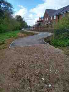
As you walk towards the new housing development you will see a tarmac path, which will take you past the site of the Roman Villa, this has now been covered over, but information boards tell the story and more can be found online here.

3
The path now crosses a private lane to a farm, go straight over with the sub station on your left through the gate into the next field, the River Cam is on your left. The dismantled railway runs to the right and you will shortly come to the concrete bridge that took the railway overhead. If you turn right here you will head into Draycott Business park, however we want to strike left, through the kissing gate and over the footbridge.In the field take the path to the right hugging the hedge on your right hand side through which can be seen the trackbed of the railway. Follow the field boundary to the end and then up to the left to a stile.
Over this stile it almost looks like we are in an old lane, follow this round the corner, to the footpath sign and stile pointing left. Here you have a choice…
Continuing on the lane the field path turns into a tarmac track and the back of one of the Mills (known as Sundeala or Sunbury Mill there is some interesting information available on their website about the history of the mill https://sundeala.co.uk/sundeala-story/). Following this through will bring you out into Courthouse Gardens and if you turn left at the end a short walk will bring you to Tesco. Returning from the Sundeala Mill to our field path we retrace our steps to the footpath sign and stile (we originally passed on the left and now turn right, follow the path to the right around the field to the next stile, which we will go over and head across the middle of the field ( you will be able to see St Bartholemew’s Church, Cam over the trees) Over the next stile and through a narrow tunnel of vegetation by the old railway will bring you out at Rackleaze Wetlands Area and the board walk. This is a natural marsh area, which should have pools of water. If you follow the board walk and path it will take you out by Cam Memorial Hall and once again it is just a short walk to Tesco's from here.
Returning to our field path we retrace our steps from the stile into Rackleaze back to the previous stile/gate – staying in this field and turning right, with the hedge immediately to our left we follow this path almost straight to the end of the fields and then through a paddock towards Upthorpe Road, with houses on our right. Left, through the gate onto what looks like someone’s drive and at the end take a sharp right down the hill which will bring you out near the Railway Inn.
4
Turn right and walk towards Cam and then turn left into Everlands and past Cam Mills. Cloth is still produced here for snooker tables and for tennis balls that are used at Wimbledon.Continue along Everlands past the scout hut and beyond until you see the old railway footbridge, turn left here and follow the path through the copse (crossing the river, which has reappeared) it brings you out in St George's Close and directly across the road is a narrow footpath, which will take you through to Church Road.
5
Turn right down the hill to the bridge and turn left. You can walk on either side of the river here as there are footbridges that cross it. Turn left to the new estate and enjoy the level walking by the river, before heading up Budding Way and round to a brick path which will take you through to the bottom end of Long Street.6
Walk up Long Street towards the Chantry Centre, (the big cream building on the left hand side). Just before you get to it you will see a footpath sign pointing down the lane to houses, turn left here and follow the path past the houses, which will bring you to what is known as St Mary’s Well, the Nuns' or Dipping Well – this, along with Broadwell, would have been where the villagers would have come to collect their water before piped water was available.Continue to follow the path round (a turn up to the right will take you to Broadwell which can also be accessed through St James' Churchyard and/or Silver Street), our walk continues by turning left down Water Street, with the stream on your left.

7
Some 100m below the Broadwell springs there used to be a swimming pool in the mid 19th century, it was over 30sq m, varied in depth and was heated to 18 c. Due to lack of subscriptions it closed in 1880.At the bottom of Water Street, cross over Lister Road and continue down between the houses to join the Rope Walk, this is a pleasant level route next to the River Ewelme follow this path with the houses on the right then pick up the footpath that follows the stream.
8
At the intersection, here turn right then left towards the large tarmac area and manor houses, heading for the footpath sign in the corner that once again takes you by the River Ewelme on your left, then, joining Ewelme Close, and following the track at the end, this will take you up to Uley Road and go up the flight of steps opposite. This will bring you to Rivers Mill and the mill pond (the former Mawdsley’s Factory – now housing).Turn right over the bridge of the mill pond and follow the path through the houses, as you come past the mill pond bear left, joining the road and then bear right, taking the path up past these houses towards the wooded area with Highfields estate to your right, through the green rails, turn immediately back on yourself to the left and go through the old iron rails into the wooded area onto the track with a green arrow sign. Head up the incline towards the open field in the distance where you will see a building – this was until 1934 the main pumping station for Dursley (built circa 1900) and finally decommissioned in 1953. The building was derelict for many years before being renovated as a private dwelling in 2012.
9
Continue to follow the path, which narrows into a wooded area before coming out onto an open track.At the end go through the kissing gate and turn right follow the hedge and then over the stile joining Ganzell Lane. Continue along it and then take a right to come down past Castle Stream Farm, where there is a gate. This track leads down to Caswell Pumping Station built in 1935 to assist with the ever increasing demand for water, sited over Caswell Springs this pumping station used pumps manufactured by Lister's for around 20 years before these were changed in the mid 1950’s and diesel was replaced by electric motors.
If you wish, take a look go through the second gate and explore. Otherwise turn left through the hedge and stone area, then follow the track across the field.
10
You come to some steps and a pathway through to Wordsworth Road, turn right onto Chaucer Road and then left onto Tennyson Road, follow this round to the right and then left onto Somerset Avenue, continue on Somerset Avenue down past Welling Close and turn right at the end into Rosebery Road.At the end of Rosebery Road a left turn will take you up Uley Road to the top of Bull Pitch and back into Dursley.
Enjoy your walk!
Why not join our Insiders and stay up to date with walking events around the Dursley area …
Join our Insiders
Get advance notification of
- walking events in and around Dursley
- early preview of festival programmes
- wait list access to booked out walks and more …
Pop your email address below and we’ll keep you in the loop
Your email address is handled in accordance with our Privacy Policy
